Walkabout: Travel Life and Photographs

Augh!…….

November 24, 2005 

So yesterday I’m having a great day right? Doing a whirlwind tour of the rest of the sourther south island, seeing the Catherdral Caves, the most southern point, a lighthouse, and all this stuff……and I pull into Dunedin where I planned to stay the night. Not more than 2 minutes into the city the speed limit gets cut in half to 50 on a downhill. So I start braking and get it down to 65 when I copper spots me coming the opposite way, flings around, and pulls me over….I explained the situation to him, but he wasn’t having it, pulled the whole GIGO.  Garbage In, Garbage Out. Said I was going a “wee-bit too fast” and wrote me up an $80 dollar ticket. I was soooooo pissed! I still can’t believe. The worst part was when I pulled back on to the road and it switched back to 100kph. Which means for about 1/2 a mile the speed limit was 50 for whatever reason. And I make every effort not to speed here, usually find it hard to, get passed all the time, and then this happens. It gets away from me once and now I’m paying for it! Augh!….

Stepping Back In Time..

November 22, 2005 

So today I was headed up to Milford Sound, and stopped off at the petrol station to fill up the tank. Before I even got out of the car a lady came out and started pumping the gas for me. It was like I stepped back in time or something. I have to admit I didn’t care for it, felt strange, and then she offered to check the oil and clean the ‘windscreen’, but I said I already took care of it and it was not needed.

Queenstown and Beyond

November 21, 2005 

Just when I think I’m actually getting used to the roads and rules in New Zealand they go and throw something new at me. It definitely took some time to get used to everything being backwards like driving on the left side of the road and having the steering column on the right side of the car, but I’ve been adapted and adjusted to this and it seems second nature anymore. Although I have to admit I still get into the wrong side of the car at times. New Zealand is filled with numerous one lane bridges, some fords, a dotted passing line that never seems to end even around corners for anyone so daring, road construction crews working without the Stop and Go sign people leaving you to pass through as you can and see fit, and a 100kph speed limit on all open roads which seems impossible to fulfill most of the time. Most the roads remind me of those found in the Loveland and Boulder canyons back home. The other day though when I was headed out to Glenorchy from Queenstown the two lane road suddenly became one with little warning and no reduced speed limit sign. It made me slow
down though and take caution as I drove around the curves and hoped no one else was coming from the opposite direction. At one point however another vehicle came and I was forced to back up into a wider spot back so he could pass by and then I went on my way…………..what next?

It happened all the time in South America, numerous times some days as I seemed to be a magnet with my long hair, but it took nearly two months for someone to approach me wanting to sell. The Maori guy was hard to understand and basically had to spell it out of me only to make me laugh when he spitted it out of his mouth full of food. He carried on and I went on about my business.

I spent some time in Queenstown which reminded me much of the resort towns off of I-70 back home like Keystone, Winter Park, and so forth apart from the lake which it cradled next to. I did about the first day and a half of a hike called the Routeburn. It’s one of the more popular multi-day hikes that takes most 3-days to accomplish the non-circular hike that ends near Milford Sound. I went as far as a place called Harris Saddle before turning back that is suppose to have spectacular views, but I saw little more clouds clinging to the peaks. I may try it again from the opposite direction now that I’m in Te Anau and plan to head to Milford Sound next. Apart from that I have been taking it easy since my right calf muscle has been giving me some grief recently, and plan to stay off it for at least a few days.

Somehow in Queenstown I put myself 12 miles out of way on a hike one day by missing a turn somewhere. Luckily I met some peeps on another trail who offered a ride to me back to town. Normally I wouldn’t hitch, don’t want to take the risk, but she seemed nice enough and appeared to be showing her parents around. Turns out she and her husband have been coming to NZ for the past 8 years following the ski season and working as instructors, and then returning to Switzerland where she and the parents were from to do the same there. Her husband was actually from South Africa. What interesting world we live in, and it’s great to see how some go about their lives in it.

My parents come in little more than a week! I am looking forward to that as well as my super-hot girlfriend visiting me shortly after! Rachel has just finished her first project with Americorps. She spent four weeks in Mississippi helping clean up the aftermath of hurricane Katrina, and now looks to head to the Smokey Mountains of North Carolina before Christmas break.

I lost my big toenial today, finally! And yes, it is a normal thing…

Wow! Today was awesome. I went out to the Mount Aspiring National Park and don’t know if I had more fun on the trail or just getting there. It’s about 50K outside of town to get there. The first 30K is on paved roads with two-lane bridges, the next 15K is on gravel roads with one-lane bridges, and the final 15K is on a one-lane gravel road with no bridges. So I got to drive the Toyota through 8-10 fords of various sizes! It was soo fun! Glad I didn’t get stuck either. Heck, if I would have known the Corolla could drive through small streams I would’ve paid the man I bought it from full asking price. It’ll definitely be a selling feature I’ll point out when I get rid of it later on.

The hike was great as well. There was a swing bridge suspended 50 feet up over a river, and boy did it swing! The trail followed a well sized glacial stream from which you could see snowfields, sheer rock cliffs, waterfalls, nice alpine scenery, and Rob Roy Glacier at the end. Very nice and easy trail that was popular today and I even met a woman from Telluride, CO. A few of us sat up there underneath the glacier having lunch, chasing off the pesky Kea birds, and watched probably 2 dozen small waterfalls spout off the glacier’s side, and at times here it creek, crack, and drop chunks of ice off the cliff it hugged to the rocks below. But I have to admit part of me just wanted to drive through the fords again! Here’s one of the pictures I took along the way.

The pics didn’t all turn out so hot because the snow was so bright I think. Anyway, this is me in front of Rob Roy’s Glacier.

Long Time Coming

Whew~ It’s been a while since I’ve written on here. Lately I’ve been grappling with the decision of work. The questions of course entailing: “Do I want to work?”, “If so, where do I want to work?”, and “What do I want to do?”. And after tossing it back and forth for a while traveling about I’ve decided that I actually don’t want to work here. I mean I do have a Working Holiday Visa that allows me to live and work here for up to a year, but now after seeing a large bulk of New Zealand there hasn’t been a place that I want to call home, or that I feel like I could call home. Don’t get me wrong, most the cities I’ve been to have been great and make traveling within New Zealand very easy. Unfortunately none of them aspire to more than a visit. Plus even if I were to work in my field I’d prolly have to go to one of the big cities, which haven’t suited me at all. Even Christchurch that I thought would be comparable to Fort Collins was too much. So at this point that’s where my decision is and plan to continue traveling on and see and do everything to my hearts content that I could ever want here in
New Zealand. After that…….who knows? I’m still waiting to see where the pieces fall….maybe travel on to Australia, New Guinea, Thailand, etc…etc…, come home and work, plan for an Around the World trip later on, buy a small house with a white picket fence, propose to Rachel, and settle down while starting a family (Heehee, that one’s for the parents!), or go back to school in Arizona……..like I said who knows! It’s anyone’s guess at this point!

After Arthur’s Pass I moved on to a little town on the west coast called Hokitika for a night. There I saw locals fishing or rather netting with large poles a local delicacy called “white bait.” It was a small little, clear fish with big, googly eyes that catches a whopping price of $50 bucks/kilo. Next I stopped in Franz Josef Glacier where I saw……wait for it……a glacier! Very impressive I might add. I had never seen one before and was in awe by the shear mass of it.

There I also ventured into the Tatare Tunnels. TUNNELS mind you, not CAVES. Big difference there! But not really……..It was fun though and reminded me of my childhood when my friends and I would try to muster up the courage to walk through a large storm sewer near the neighborhood. I used to be scared then and I still do today apparently. Granted it could have been because of the Piri Piri Caves incident, but let’s not talk about that. Anyway, I ventured into the tunnel with torch in hand. The tunnel was around four feet wide and ranged in 5-6 feet high, and at any given time there was 1-4 inches of water on the floor flowing in my direction. I took my time entering watching my foot placement as not to slip and periodically looked back to see light peering through the entrance. After a while though the tunnel shifted enough to where no light could be seen behind or in front of me. This is when I started to freak myself out because as that happened I began to hear a low rumbling sound. I paused…..thought…hmmm, what could that be?……perhaps a helicopter giving a tour of the nearby glacier……and walked on…..but the sound persisted and made me reconsider my decision as I advanced on…….doing so made the rumbling grow louder……..huh……I thought that was interesting……and then somehow formulated an impossible scenario in my head that consisted of a large tropical storm forming high above the mountain range, dumping thousands of gallons on the surrounding area, and having all that water pool in one central location before plummeting down the mountain and into the tunnel shaft that I had entered…..impossible I knew, especially since they allow people to enter daily…..but I kept thinking of it…………and the rumbling increased…….I paused…..bent down and tightened the straps on my sandals just in case I had to make it run for it….and went on……………………………………..And then……………..I saw light! Nothing of course happened; it was all in my imagination……I came out into a large trough that extended
out 20-30 feet before attaching to another tunnel. Laid above and over part of the trough was a large metal sheet which was being punished either by a small stream or run-off from the night before, and that’s what had been causing the rumbling the entire time! I glanced into the next tunnel, but noticed it was blocked off by a gate, and then turned back and out of the area.

Next I traveled to Wanaka stopping off in Fox Glacier along the way where I saw……..wait for it……a glacier! Still impressive, but not as good the second time around. The drive over Haast pass was beautiful and I stopped several times along with everyone else to snap a few photos and take and in the views. Wanaka is
nice as well and I have spent the last few days exploring the area, but plan to move on to Queenstown either tomorrow or the day after.

On top of Roy’s Peak overlooking Lake Wanaka, Lake Hawea, the town, and so forth.

4 Hikes, 3 Nights In The Car, 2 Sore Legs, 1 Tired Andy

Avalanche Peak (a.k.a. The coolest peak name in existence) was very difficult to say to least. Sitting in the Southern Alps, just outside a little town called Arthur’s Pass; where the mountains create their own weather and make it rain 175 days a year on the village. The peak is reachable via two routes, Avalanche Peak Trail and Scott’s Track. They recommend ascending Avalanche Peak Trail and descending Scott’s Track since it’s not as steep and rigorous, or Scott’s Track both ways to make it even easier. The two tracks meet up for the last few hundred meters before the summit.

The pouring rain made me wake up several times as I was sleeping in my car, but to my surprise all had cleared by morning. There were blue skies all around and high winds everywhere. Not knowing what the afternoon would bring I hurried up and began climbing the track located right next to the visitors center. Within minutes I was scrambling up rock walls on the Avalanche Peak Trail and in no time at all I could look down on Arthur’s Pass. The buildings, cars, and train all looked like little toys. I only paused briefly and continued on the flooded trail. When the wind ceased you could hear it trickling down the mountain and in between the rocks.

The scrambling finally stops once you reach the bush-line and levels out more as high alpine grass sweep across in front of you hiding the path. Large, yellow poles dot the landscape now and help you keep in route to the top as the trail will disappear on and off again. The next big climb makes you scuttle up a ridge with a descent drop-off to your left. Nothing much to worry about unless the winds are treacherous like they were for me. I did my best to stay to the far right of the track and get on all fours if necessary. This is also where I passed a group of three on their up, but I never saw them again as I came down and can only assume they turned back due to the weather. Next you must cross a small saddle fully exposed to the elements. I got knocked and pushed around by the wind and seriously considered turning back at this point. Being advised not to descend Avalanche Peak Trail though I didn’t know what to do and decided to go on. Next the trail disappears and lets you choose a path of your liking as you go up a boulder field, which at times might be covered by snowfields. I did my best to avoid them by taking a longer way around, but did end up passing over two smaller fields. Once the top is reached the path is joined by Scott’s Track. And from this vantage point I could see a storm coming in from the west, but knowing the two trails only joined for the last stretch I risked it once again and aimed for the top. The last leg is along a rocky and crumbly ridge drop-offs on both sides. I tried to stick to the eastern side of the ridge as much as possible to avoid the gusts of wind coming in from the west. Some spots were openly exposed and there was no way around it. So I would sit tight, wait for the wind to die momentarily, and then figuring it was smart to stay low I would dart across on all fours to another sheltered area. And then I was finally there! I didn’t stay long however, just enough to snap a few photos, get pestered by some local Kea birds interested in my shiny camera, and get the heck out of there and back into the bush. I took Scott’s Track down and ran into some others attempting to the peak, but they all turned back due to the storm rolling in. All in all a very exciting and scary hike at times, this would prolly be more enjoyable on a calmer day if they get them around here.

I also did a few other hikes, Bealey Spur Track, Devil’s Punchbowl Falls, and Bridal Veil Falls. These were descent hikes and only made my sore muscles ache more having climbed Avalanche Peak first. From here I plan to move on to Greymouth located on the West Coast and maybe take it easy for a bit before heading further south to catch up with some glaciers.

Akaroa Akaroa Akaroa

Mount Fyffe proved to be much more than I thought it would be. Just outside of Kaikoura lays the parking lot to the base of this peak. I don’t know how I pick all these steep uphill hikes, but this was by far the most challenging one I’ve done yet. Starting out at sea level this hike gives you no time to warm up what-so-ever, and takes you up 5,000 feet in a matter of 3-4 hours if your pace holds strong, and coming back down isn’t much faster.

I took a chance on this one because the weather wasn’t clear when I embarked on this journey, but the clouds looked to be hanging rather low and figured I might be able to hike through them and meet the sun on the other side. So starting out was of course wet and drizzly and rather nice. The clouds kept me cool by depositing a thin layer of water across my arms and face. I could even see the rain build up on my arm hair and slowly drip off only to be replaced by another. At one point it became so thick I could see only 10-15 feet in front and back of me. The trail slopped off at both sides and I couldn’t see past its edge. For all I knew I was walking next to either a pretty meadow or a cliff that dropped straight off. I envisioned the meadow. But eventually as I climbed further and further up the mountain I could see the suns bright orb shining through and within an hour or so I broke out to see snowcapped mountains to the north. I snapped a few photos and while I did the clouds rose to engulf me once again. I hurried along and left them behind for good. Next I came across a flat ridge where a hut stood for people wanting to stay longer. Seemed very nice and cozy inside with bunks and a wood burning stove, however not planning on staying there I took in the view. I could now see the snow covered peaks, a blanket of clouds covering the land to the south and west, and the blue, blue Pacific to the east. And it only got better once I reached the top. Having a bite to eat I watched the clouds slowly burn off to reveal the land below and the small peninsula that Kaikoura seemed to cling to. 

The next day I continued on South passing through Christchurch on the way to Akaroa where I’ve been for the past couple nights. Akaroa is a very pretty place with a small bay and large hills that seem to circle around the French settled town. It has some descent walks to do if you can follow or find the signs. I got lost on several occasions. The highlight though was seeing a peacock on one of them. It must have measured six feet in length from head to its bottom feathers, and let out the most awful screech when I got to close. The kind that makes a person jump back when they’re not expecting something so dramatic.

From here I plan to head to the west coast and stop off in Arthur’s Pass along the way. (Sweet~I just fixed the guys internet connection that he was having problems with here at the camp place. Said he had a computer guy coming out tomorrow to look at it, but said he wasn’t like me. Those comments always make ya feel good. And the crazy thing was he was just in the States traveling for 5 months. He was even in Estes! Stayed at Mary’s Lake Campground and absolutely loved it.)

South Island Baby

I took off…..a while ago from Taupo and decided to head to Wellington, which ended up being my longest travel day thus far. Most the towns are nice and close and travel days have not been more than two hours in the car. It’s nice because it doesn’t take up a day, you can arrive somewhere and still have the afternoon to explore. The drive from Taupo to Wellington cut through some military training grounds where signs were posted saying to keep moving and that live ammo and explosions could occur at anytime. Made me kind of nervous, but at the time I was hoping I’d see a cadet lob a grenade into a vacant building and watch the thing torch down.

Wellington proved to be another big city to me, and I got to experience all those nice flavors that come with it. I got caught up in rush hour traffic, got lost, and even got a parking ticket. I tried to meet up with Ash’s Mom and Sis (a friend of mine that I worked with back at the YMCA from NZ), but when that didn’t work out I decided to get out as fast I could. This meant taking a ferry at 3:00 in the morning to the South Island, and only catching a couple hours sleep on a sofa half my size onboard.

Picton is the small gateway town the ferry drops you off at. It’s pretty with the Sounds being the main attraction. Apart from that though I felt the scenery was much the same of that in the North Island and only spent a couple days there anxious to see something new. So yesterday I headed further south and watched
the crowded hillsides become more populated by trees, less by thick bushes and shrubs, and at one point nothing at all until reaching a small town called Kaikoura. Kaikoura is where the ocean meets the mountains. Who knew you could have the best of both worlds in such close proximity to one another. Like I did a hike around a peninsula where I encountered a fur seal colony and at the same time was able to turn around and see and snowcapped mountains. Pretty incredible. I plan to summit one of the mountains before moving on assuming, as always, the weather clears since the rain decided to rear its ugly head once more today.

E-Mail Message

October 26, 2005 

Hi Everybody,

Just wanted to write a quick note and let everyone know how I’m doing.

It’s been nearly a month since I left the States and came to New Zealand. So much has happened between now and then I don’t know where to begin really……

Then I first arrived in the country I was greeted by a New Zealand family (Kerry, Darrell, and daughter Paige) that I was put in contact with from a friend back home. They were great by taking me and giving a very warm welcome to this great country of theirs. They helped me setup a bank account, get my Visa paperwork situated, showed me around, taught me about their culture and country, and even helped me buy a car.

That’s right; I am also the proud owner of two vehicles now. I purchased a 1991 Toyota Corolla to travel around in while I’m here. It has fewer miles on it than my car back home. Before I purchased the car I traveled around up North a bit by bus. It helped me decide if I wanted to buy one or not. By the end of it I knew it would make all the difference because it allows you to have so much more freedom and capability to do more. Once the bus dropped you off you were on your, and although I don’t mind walking places it was a bit excessive. I remember walking to a 10K hike, which took me an additional 10K or more just to get to it by foot. And then you have to walk to the store, the post office, the backpackers, blah, blah, blah…

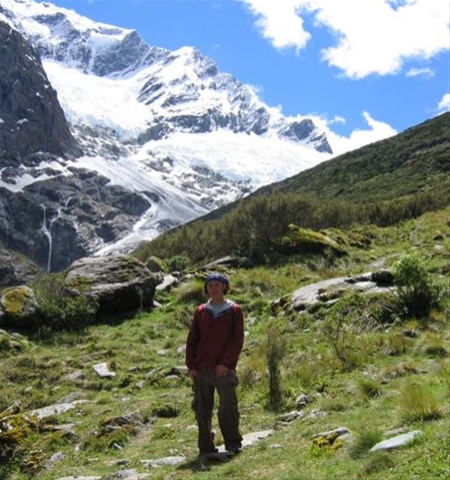
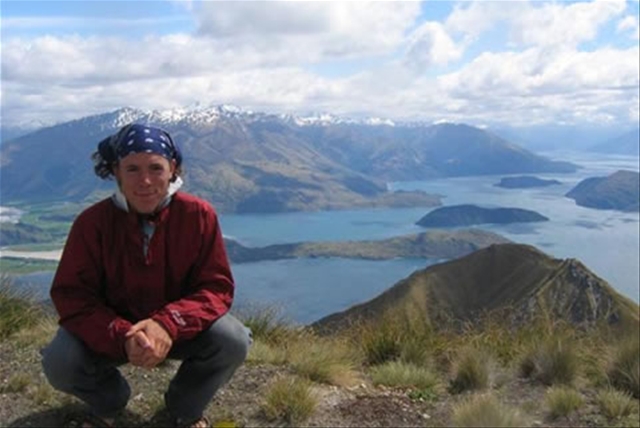
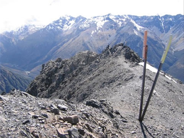
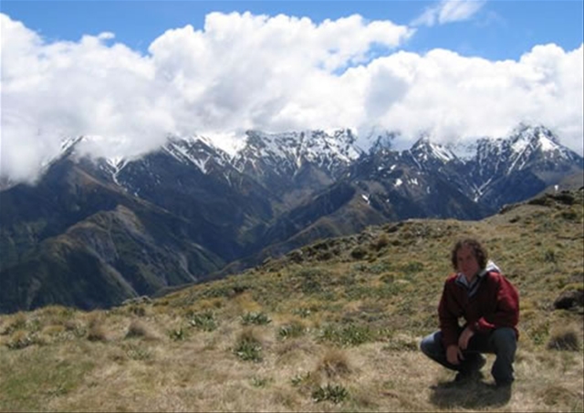
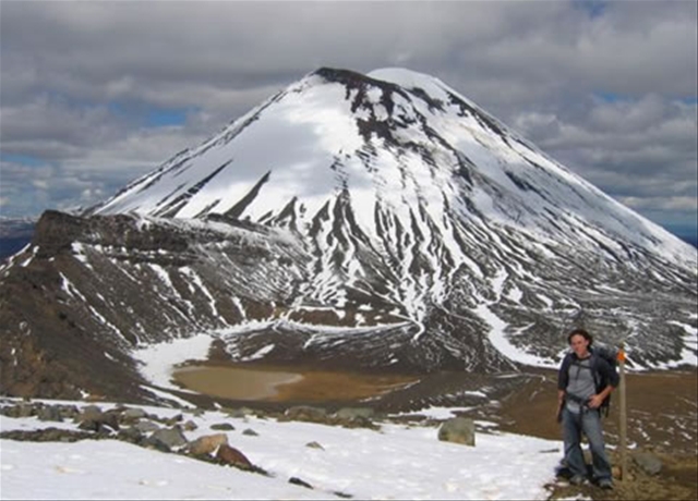
I’ve traveled a descent amount around the North Island and at the moment am waiting for the 3:00a.m. ferry to arrive in Wellington to take me to the South Island. On the North Island I’ve stopped in towns starting from the top Paihia, Orewa, Auckland, Waitomo Caves, Rotorua, Taupo, and Wellington. I won’t go into detail on all them, but have kept busy by doing numerous hikes in and around all the areas, visiting cultural hot spots, viewing thermal activity, learning about the history and environment, and mingling both with local ‘kiwis’ and other travels passing through New Zealand all the while trying to drive on the left side of the road. A few of my favorite things included exploring the caves of Waitomo, hiking the Tongariro Crossing around two active volcanoes south of Taupo, chasing Wallaby’s in Rotorua with a local couple named Simon and Ralene, and just viewing the natural beauty all around.

There are definitely pros and cons to traveling alone. It’s hard at times for sure, especially when you’re sick, but you meet so many people along the way. Some I’ve came to know over the course of a few days and others just over dinner. Some of them are locals to New Zealand and others are traveling abroad just as I am from all over the world like the UK, Australia, France, and Sweden. A few are even traveling around the world and make me extremely jealous. I’ve only met one other American. She was selling snacks out of her van at the end of the Tongariro Crossing and had “Go Sox” written on the bottom of her sign. I knew right away she had to be from Chicago. Most others seem to be from Germany. People running the backpackers and campsites here say it’s the year of the German. At other times it’s been the year of the Australians, the Brits, the Americans, etc…etc….

I don’t have any plans for the South Island as of yet. My routine so far has included doing all I find of interest in a town and then moving on to the next. From what people have said I have a feeling I’ll find a lot of interest in the South Island. That’s why I’ve kind of skipped over part of the North Island to have a full month there by myself until my parents and Rachel arrive later on. There’s still things I hope to do in the North, like zorbing, bungy jumping, etc…, that’ll probably be better with them. It’ll be nice to see my family and girlfriend again, and it will hopefully create a whole new type of experience in New Zealand by traveling with them.

Some of you might be wondering what my lifestyle is like. Occasionally I sleep in my car when I’m feeling extra cheap, but for the most part I live out of a tent. The campsites are pretty nice and include amenities such as a communal kitchen, bathroom/showers, and at times a pool and hot pool. My diet consists largely of Wheet-bix for breakfast (a local wheat cereal in biscuit form), peanut butter and jelly sandwiches (sometimes toasted and dipped in milk =)), noodles (much like the Ramen noodles found back home), and water and juice to drink. It’s not the most healthy and I try to throw in some bananas, kiwis, potatoes, and carrots when I think of it. And meat is a luxury I haven’t splurged on yet. Who knows, maybe I’ll come back a vegetarian! But then again, prolly not, I like meat too much. I miss it.

Anyway, hope everyone is doing well back home! I should get going as I can barely keep my eyes open and need to load my car up on the ferry here pretty quickly. If anyone is interested in more details on what I’ve done or seen be sure to check out my Blog and Pics sections on my website www.andyjcollins.com. And be sure to sign the guest book if you get a chance, I enjoy hearing from people back home!

Take Care and Miss You All, Andy

Tongariro Crossing

I’m feeling better and have been in Taupo for nearly a week. I’m getting caught up on a few things and figuring out where I’m headed next. It looks to be Wellington at this point where I will crossover on a ferry to the South Island. I hope to have about a month down there with good weather (fingers crossed) before my parents come at the end of next month with Rachel following shortly behind. Despite being sick I still managed to get out and do a few things, including the Tongariro Crossing(!), all of which can be found below. Oh yes, and I took some nice 360’s while on the Tongariro Crossing so check those out!

Tongariro Crossing – With the weather clear, the sun shining, and my cold almost gone I was able to hike on this magnificent trail. The crossing is just south of Taupo in NZ’s oldest national park and is easily accessed by bus. Since the trail is 17km (6-7 hours) one way it’s really the only thing you can do. The trail starts off easy with little uphill and plenty of boardwalks over rougher terrain, which was nice because all I did for the first half hour was stare aimlessly at Mount Ngauruhoe, an active volcano to the south with a near perfect cone. After an hour passed we reached the first rest area with a side track to Soda Springs. I chose to do the sidetrack while everyone else began the rigorous, steep climb up to the first saddle. The ascent is difficult and taunting. You look up to the next ridge, think you are there, and pull yourself up and over it only to find another ridge in your way over and over again. The pain in your legs subsides though once you reach the first saddle that crosses between two active volcanoes, Mount Tongariro and Mount Ngauruhoe, and through the South Crater. It also gives you a chance to take in the scenery and catch your breath until the next, but much smaller, ascent is reached stretching up to Red Crater. Although, the second ascent was less strenuous it did prove too much, or perhaps it was the altitude, for an older gentlemen who decided to project food from his mouth onto a neighboring boulder. From there you reach the highest point on the track, 1886m and have nothing but downhill ahead of you. The view from the top is spectacular as you can clearly see both volcanoes, the deep red in Red Crater with steam rising around its rim, emerald lakes below you, Blue Lake to the north, and Lake Taupo in the distant horizon. And was a nice place to have lunch and snap some photos. On the descent you practically fall over yourself on the lose ground and skid into the 3 emerald lakes below that are actually a group of water filled explosion craters. Once past these you walk through the snow covered Central Crater to Blue Lake where you can look back on the best part of the trail before it fades into the background as you slide around the North Crater, pass by an over night hut, and walk through alpine grass overflowing on to the path before plunging into the native forest and eventually reaching the end of the trail. The Tongariro Crossing was great in that it showed you a little bit of everything New Zealand has to offer. I don’t know if its New Zealand’s “Best One Day Hike” but is definitely one not to be missed.

Cheers to Yen, a German Chinese girl that I met on the trail, who took photos of me! Good luck to you on the rest of your around the world travels and I hope you enjoy South America as much as I did.

Craters of the Moon – A nice, short loop around a very active thermal area with plenty of steam rising up everywhere and that foul sulfur smell in the air.

Huka Falls – A good walk around the teal colored river taking you past a hot river that anyone can freely enter, through native forest, and ending at the falls. The falls were impressive because the river which normally runs 70-100 meters wide is forced into about a 10 meter wide rock channel. The force you feel by standing over the falls on the bridge is incredible and makes for a nice waterfall as it shoots out into a wider body of water.

Aratiatia – Taking off where the Huka Huka Falls trail ended the Aratiatia Trail begins. It doesn’t take you through anything epic or unique not found anywhere else in the northland besides what I call ‘dead forest’. But according to a couple I met coming back on the trail they said it was living and the trees were purposely planted too close to each other. This made them grow straighter and faster by reaching up for the sun and of course easier to cut down when the time was right. Anyway, the trail lead to a hydroelectric dam. Normally the water is diverted elsewhere, but four times a day is allowed to freely run its natural course. So from a few vantage points you can watch the dam gates rise to the fall of water which quickly pools up and cascades down the mountainside.