4 Hikes, 3 Nights In The Car, 2 Sore Legs, 1 Tired Andy
Avalanche Peak (a.k.a. The coolest peak name in existence) was very difficult to say to least. Sitting in the Southern Alps, just outside a little town called Arthur’s Pass; where the mountains create their own weather and make it rain 175 days a year on the village. The peak is reachable via two routes, Avalanche Peak Trail and Scott’s Track. They recommend ascending Avalanche Peak Trail and descending Scott’s Track since it’s not as steep and rigorous, or Scott’s Track both ways to make it even easier. The two tracks meet up for the last few hundred meters before the summit.
The pouring rain made me wake up several times as I was sleeping in my car, but to my surprise all had cleared by morning. There were blue skies all around and high winds everywhere. Not knowing what the afternoon would bring I hurried up and began climbing the track located right next to the visitors center. Within minutes I was scrambling up rock walls on the Avalanche Peak Trail and in no time at all I could look down on Arthur’s Pass. The buildings, cars, and train all looked like little toys. I only paused briefly and continued on the flooded trail. When the wind ceased you could hear it trickling down the mountain and in between the rocks.
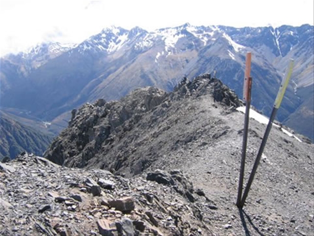
The scrambling finally stops once you reach the bush-line and levels out more as high alpine grass sweep across in front of you hiding the path. Large, yellow poles dot the landscape now and help you keep in route to the top as the trail will disappear on and off again. The next big climb makes you scuttle up a ridge with a descent drop-off to your left. Nothing much to worry about unless the winds are treacherous like they were for me. I did my best to stay to the far right of the track and get on all fours if necessary. This is also where I passed a group of three on their up, but I never saw them again as I came down and can only assume they turned back due to the weather. Next you must cross a small saddle fully exposed to the elements. I got knocked and pushed around by the wind and seriously considered turning back at this point. Being advised not to descend Avalanche Peak Trail though I didn’t know what to do and decided to go on. Next the trail disappears and lets you choose a path of your liking as you go up a boulder field, which at times might be covered by snowfields. I did my best to avoid them by taking a longer way around, but did end up passing over two smaller fields. Once the top is reached the path is joined by Scott’s Track. And from this vantage point I could see a storm coming in from the west, but knowing the two trails only joined for the last stretch I risked it once again and aimed for the top. The last leg is along a rocky and crumbly ridge drop-offs on both sides. I tried to stick to the eastern side of the ridge as much as possible to avoid the gusts of wind coming in from the west. Some spots were openly exposed and there was no way around it. So I would sit tight, wait for the wind to die momentarily, and then figuring it was smart to stay low I would dart across on all fours to another sheltered area. And then I was finally there! I didn’t stay long however, just enough to snap a few photos, get pestered by some local Kea birds interested in my shiny camera, and get the heck out of there and back into the bush. I took Scott’s Track down and ran into some others attempting to the peak, but they all turned back due to the storm rolling in. All in all a very exciting and scary hike at times, this would prolly be more enjoyable on a calmer day if they get them around here.
I also did a few other hikes, Bealey Spur Track, Devil’s Punchbowl Falls, and Bridal Veil Falls. These were descent hikes and only made my sore muscles ache more having climbed Avalanche Peak first. From here I plan to move on to Greymouth located on the West Coast and maybe take it easy for a bit before heading further south to catch up with some glaciers.
 We travel: to learn and grow, to challenge ourselves, stretch our limits and foster an appreciation of both the world at large and our own back home.